About BaseMap: Hunting Maps and GPS
Precision land ownership maps and industry leading GPS tools for hunters and outdoorsmen. OFFLINE GPS and TRACKING • Cache maps for offline use without service. • Save as many offline maps as you want with unlimited
Precision land ownership maps and industry leading GPS tools for hunters and outdoorsmen.
OFFLINE GPS and TRACKING
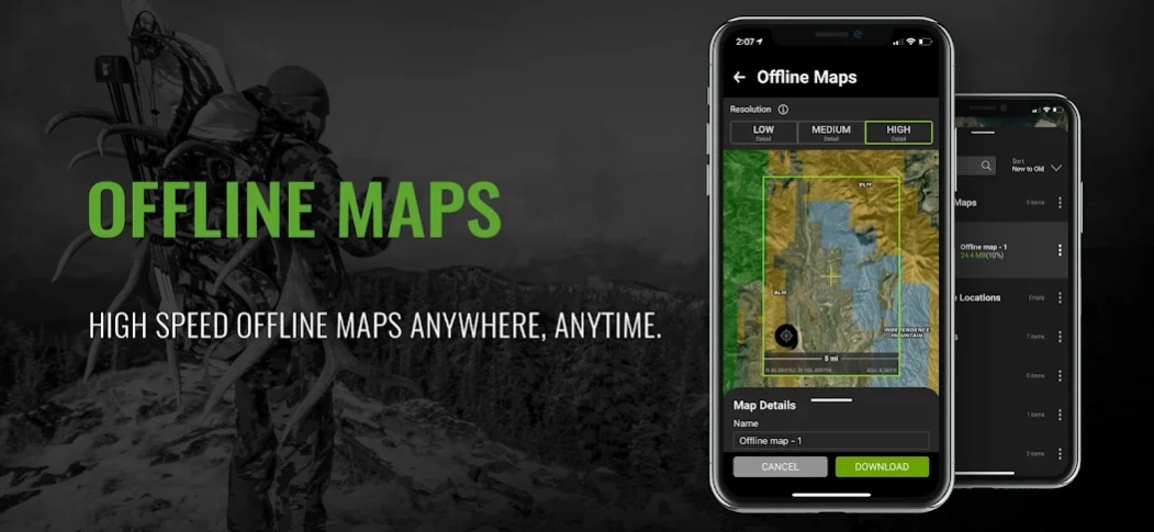
• Cache maps for offline use without service.
• Save as many offline maps as you want with unlimited caching (Pro).
• Know exactly where you are in real time even without cellular coverage.
MAP LAYERS
• Over 800 layers and growing
• Nationwide Color Coded Govt Lands
• Nationwide Private Parcel Boundaries & Owner Names
• Water depths for East coast, West, Coast, Gulf coast, & over 4,000 U.S. lakes
• Nationwide Hiking Trails
• Nationwide Wildfires & Timbercuts
• Nationwide Wilderness & Roadless Areas
• State specific hunting layers including hunting unit boundaries, private hunting opportunities, WMA’s & more
• Multiple Topography & Satellite Imagery basemap options
• Much more
LRF MAPPING (Laser Rangefinder Mapping)
• Use your rangefinder as a powerful mapping tool
• Precisely mark the exact location of distant targets with ANY rangefinder
• Recover game, build routes, plan stalks, lookup distant property owners and more, all using your rangefinder!
MOBILE GPS
• Know your exact location even without cellular or WiFi service
• See where you are in relation to property boundaries, roads, trails, peaks, or boundaries
• Navigate to trail heads, favorite places, markers, or anything you need to locate with our powerful Search and GoTo features.
XDR (Exact Direction & Range) NAVIGATION TOOL
• Easy Point and Go navigation
• Know the exact distance between you and your destination.
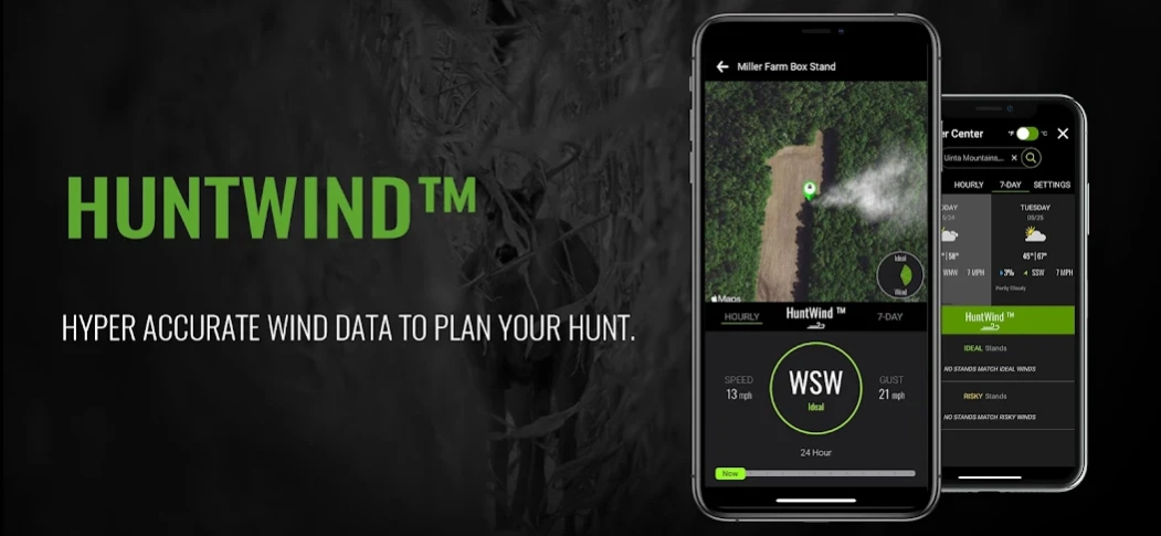
HUNTWIND™ & WEATHER CENTER
• Wind forecast to better plan your hunt.
• Know the exact day and time to hunt a particular stand and visualize wind direction and scent drift in relation to your location.
• Forecasts, temperature, moon phase, sunrise/sunset, wind, and more.
LOCATION SHARING
• Know exactly where your hunting partner is located
• Real-time updates
OUTDOOR JOURNAL
• Capture, log, and share all your outdoor adventures with the BaseMap community
• Real-time location sharing so friends can see where you are in case of emergency (connection reqd.)
• SmartMarkers - Automatically capture the weather conditions at the time you add a marker.
HARVEST LOG
• Log your hunts as detailed as you'd like. Record your hunt type, species/size, weapon, unit/GMU & much more.
GEARDROP
• Drop your marker closest to the GearDrop marker & win free gear.
GOOGLE EARTH INTEGRATION
• Export markers and view them right in Google Earth
• View the terrain in true 3D
DESKTOP APPLICATION
• Automatically sync all your data between your phone and the BaseMap web application.
SUBSCRIPTIONS
BASIC (Free)
• No Ads
• Connect with friends
• Hybrid 3D Imagery (map tilt).
• XDR Navigation
• Nationwide Roads, Trails & Points of Interest
• Nationwide Lakes, Rivers & Streams
• Hunting Unit boundaries
• GPS Location & Tracking
• Hi-Res Satellite Imagery
PRO ($34.99/yr)
• Everything in Basic plan
• Access to over 800 Layers
• Unlimited Data & Offline Use
• Nationwide parcel boundaries and owner names
• Nationwide color-coded government lands
• Google Earth Integration
• Import/Export KML and GPX with BaseMap web application
• Real-Time location sharing
• LRF Mapping (Laser Rangefinder Mapping)
PRO BUNDLE ($69.99/yr)
Includes:
• BaseMap Pro subscription
• HuntScore subscription for draw odds, harvest data, application tools, and more
• Global Rescue subscription for field advisory and rescue services
• $175 value
For questions or more information, contact us at:
[email protected]
Privacy policy: https://www.basemap.com/privacy-policy/
Terms of use: https://www.basemap.com/terms-of-use/
Previous Versions
Here you can find the changelog of BaseMap: Hunting Maps and GPS since it was posted on our website on 2016-12-26 15:12:16.
The latest version is 5.2.13 and it was updated on 2024-04-22 18:22:46. See below the changes in each version.
BaseMap: Hunting Maps and GPS version 5.2.13
Updated At: 2024-04-08
Changes: In this update we made improvements to BaseMap Connect and Bluetooth connections with compatible devices.
BaseMap: Hunting Maps and GPS version 5.2.12
Updated At: 2023-10-24
Changes: Introducing another industry first from BaseMap…the NavCam™. You can now add Remote Markers with precision by viewing your target in real-time. Utilize remote markers to recover game, plan detailed stalks, scout distant areas, finding sheds, navigate safely, and much more. The NavCam™ will make you much more efficient and effective in the field. Best of all it will work with ANY rangefinder! Give the NavCam™ a try and see what you’ve been missing.
BaseMap: Hunting Maps and GPS version 5.2.5
Updated At: 2022-04-13
Changes: Introducing another industry first from BaseMap...the NavCam(TM). You can now add Remote Markers with precision by viewing your target in real-time. Utilize remote markers to recover game, plan detailed stalks, scout distant areas, finding sheds, navigate safely, and much more. The NavCam(TM) will make you much more efficient and effective in the field. Best of all it will work with ANY rangefinder! Give the NavCam(TM) a try and see what you’ve been missing.
BaseMap: Hunting Maps and GPS version 5.1.9
Updated At: 2021-12-04
Changes: We have partnered with Global Rescue to offer our users access to field rescue services in case of emergency. Users now have access to emergency services from within the BaseMap app allowing for immediate access to rescue services.
We Improved the Remote Marker experience with the ability to continuously range targets/objects when adding Remote Markers to the map.
BaseMap: Hunting Maps and GPS version 5.1.3
Updated At: 2021-09-07
Changes: Introducing another industry first from BaseMap, Remote Markers. You can mark the location of any distant object by using your laser rangefinder.
Additionally, connect your SIG SAUER compatible rangefinder to automatically sync ranged target data and remote marker locations.
With remote markers, use distant targets and landmarks to your advantage. Plan stalks, build routes, view ballistic calculations, measure distances and navigate to your ranged targets.
BaseMap: Hunting Maps and GPS version 5.0.5
Updated At: 2021-07-23
Changes: **BaseMap 5.0***
*The all new UI includes a hyper-accurate digital compass and field friendly user experience.
*A new “navigation-mode” allows you to immediately know the distance and direction to your desired destination.
*All new XDR (Exact Direction & Range) line to plan and execute stalks by matching up landmarks so you know the route and distance between you and your target.
*Set your bearing in the direction of your pack, camp, or any other marker and BaseMap will keep you on course.
BaseMap: Hunting Maps and GPS version 4.2.3
Updated At: 2021-03-29
Changes: ****All New High Speed Offline Maps****
- Now with 5X faster download speeds
- Smaller file sizes allowing you to store more maps on your device for offline use.
- Offline Map Vault - retrieve offline maps no longer on your device directly from the cloud.
- Plan, navigate and share while your offline maps are downloading.
- Upgraded UI for easy navigation while out of cell range.
****Other bug fixes****
BaseMap: Hunting Maps and GPS version 4.2.0
Updated At: 2021-03-09
Changes: ****All New High Speed Offline Maps****
- Now with 5X faster download speeds
- Smaller file sizes allowing you to store more maps on your device for offline use.
- Offline Map Vault - retrieve offline maps no longer on your device directly from the cloud.
- Plan, navigate and share while your offline maps are downloading.
- Upgraded UI for easy navigation whille out of cell range.
****Other bug fixes****
BaseMap: Hunting Maps and GPS version 4.1.9
Updated At: 2021-01-25
Changes: Bug fixes.
BaseMap: Hunting Maps and GPS version 4.1.7
Updated At: 2020-11-12
Changes: New and improved weather center now with offline capabilities.
Bug fixes